
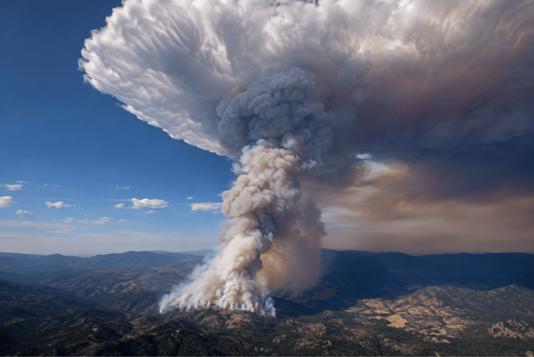
NASA is taking a closer look at one of the most unusual weather phenomena produced by wildfires: towering clouds of smoke and storm energy known as pyrocumulonimbus, or “fire clouds.”
NASA Earth Observatory highlighted new observations from Utah this week as scientists use aircraft and satellites to study how these massive clouds form and push smoke high into the atmosphere.
The research is part of a NASA-supported effort called the Injected Smoke and PYRocumulonimbus Experiment, or INSPYRE. Scientists are using aircraft and ground-based equipment to better understand what happens when intense wildfires effectively create their own weather.
What Are Fire Clouds?
Pyrocumulonimbus clouds form when extreme heat from a wildfire sends hot air rapidly upward. As the air rises, it cools and moisture condenses, creating a towering cloud that can resemble a powerful thunderstorm.
Unlike an ordinary thunderstorm, the heat source is a wildfire.
The resulting cloud can contain smoke, ash and other particles while generating powerful updrafts. Some of the largest fire clouds can also produce lightning, hail and heavy rain.
NASA has studied these clouds for years, but scientists are still learning how they influence the atmosphere and wildfire behavior.
NASA Scientists Chased a Fire Cloud in Utah
One of the most recent research efforts focused on the Widemouth 2 fire in Utah.
Lightning started the fire on July 27, and the blaze grew rapidly on August 2 amid hot, dry conditions and strong winds. The fire produced multiple bursts of pyrocumulonimbus activity that afternoon.
NASA’s Aqua satellite captured imagery showing a tall column of smoke and cloud rising above the fire. Satellite measurements indicated cloud-top temperatures below minus 40 degrees Celsius, a commonly used threshold for identifying pyrocumulonimbus clouds.
The imagery provided researchers with a detailed look at how the fire’s smoke was being pushed high into the atmosphere.
Scientists Took to the Skies
NASA and its research partners are not relying solely on satellite imagery.
Scientists involved in the INSPYRE mission are using aircraft to sample smoke and atmospheric conditions around these events. During one August 3 research flight, an aircraft flew through a high-altitude pulse of smoke associated with the Widemouth 2 fire.
The mission is designed to help researchers understand how smoke from major wildfires moves through the atmosphere and what happens when fire-generated clouds reach extremely high altitudes.
That information could eventually improve atmospheric models and help scientists better understand wildfire behavior.
Fire Clouds Can Create Their Own Weather
One of the most fascinating aspects of pyrocumulonimbus clouds is their ability to behave like powerful weather systems.
The strongest events can generate lightning, hail and heavy precipitation. Their intense updrafts can also carry smoke and particles into the upper atmosphere.
NASA researchers say some of these clouds can reach the top of the troposphere and, in some cases, push material into the stratosphere.
Once smoke reaches those higher levels, it can spread over large distances and remain in the atmosphere for an extended period.
The Phenomenon Is More Common Than Many People Realize
NASA researchers estimate that wildfires produce roughly 70 pyrocumulonimbus events around the world each year, with many occurring in forested areas of Canada and Russia. The phenomenon also occurs in the United States, particularly in areas where large wildfires create the right combination of heat, moisture and atmospheric instability.
Researchers have identified at least 13 pyrocumulonimbus events in the continental United States during 2026 so far.
Scientists have cataloged more than 700 such events since the phenomenon began receiving significant attention in scientific research during the early 2000s.
Why NASA Is Studying Them
Fire clouds are more than a striking sight in satellite imagery.
Researchers are interested in how these storms transport smoke and particles high above the surface. NASA says pyrocumulonimbus clouds may account for a significant share of black carbon and organic aerosols entering the lower stratosphere from wildfire activity.
Understanding that process could help scientists improve models of the atmosphere and better understand how major wildfire events affect conditions far above the ground.
The research could also provide useful information for aviation and wildfire forecasting.
A New Look at Wildfires in the American West
The Utah observations offer a striking reminder that a major wildfire can affect the atmosphere in ways that go far beyond the flames on the ground.
From satellites orbiting hundreds of miles above Earth to research aircraft flying through smoke plumes, scientists are gathering information that was difficult to obtain just a few decades ago.
For NASA, these “fire clouds” provide a unique opportunity to study the relationship between wildfires, severe weather and the atmosphere.
As researchers continue tracking these unusual storms across the American West, the dramatic images are giving the public a closer look at one of nature’s most powerful wildfire-driven phenomena.